
Coordinator: Natural Environment & Climate Change Agency (N.E.C.C.A.)
Partners: Institute of Geoenergy (IG), Foundation for Research and Technology Hellas (FORTH) and Hellenic Survey of Geology and Mineral Exploration (H.S.G.M.E.)
The Project is part of the Financing Program "NATURAL ENVIRONMENT & INNOVATIVE ACTIONS 2023", in Priority Axis 1 "Biodiversity Conservation Actions - Innovative Actions - Smart Cities - Other Actions".
Funding: Green Fund
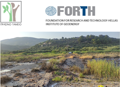
Project Summary: In the area of Lake Keri (Zakynthos Island), in addition to natural hydrocarbon leaks, there occur anthropogenic as well, resulting from last century drilling. These leaks have spread throughout the Lake, covering both its surface and the coastal areas. At times, depending on lake-level fluctuations, the leaks also extend to the coastal front, which is considered as one of the most well-known and important tourist destinations, but also an ecological breeding ground for the sea turtle Caretta caretta (southern part of Laganas Bay). The Project envisages the control/ termination of hydrocarbon leaks originating from three main drilling wells and the management of the produced liquid and solid waste in the intervention area. At the same time, a recording/monitoring system for the natural network of hydrocarbon outflows will be developed, a) for its monitoring, and b) for its possible impact from interventions required for the restoration of the ecological processes of the wetland.
The scientific approach aims to on-site sampling and analysis of liquid and solid samples, before and after the intervention (pilot application), followed by a qualitative and quantitative determination of the pollution in the most polluted sector of the wetland. In a next stage, pollution control will be attempted through the safe sealing/killing of three hydrocarbon wells and the management of existing liquid and solid waste, followed by new sampling. The results of the fieldwork will be supported by detailed mapping of the area of interest using drones with integrated special sensors for the visualization of the dispersion, allowing the recording of possible changes in the habitat after the specific intervention. Finally, the pilot program will attempt to propose an environmental monitoring system of the outflow network, which will aim at better management and restoration of this very special habitat and geosite.